ArcGIS Living Atlas of the World သည် တစ်ကမ္ဘာလုံးမှ ပထဝီဝင်သတင်းအချက်အလက်များ ရရှိနိုင်သော နေရာဖြစ်ပါသည်။ ArcGIS Living Atlasတွင်ရှိသော မြေပုံများ၊ အက်ပလီကေးရှင်း(application)များ နှင့် layer များသည် အသုံးပြုသူများ၏ လုပ်ငန်းများကို အထောက်အကူဖြစ်စေပါသည်။
အကြောင်းအရာ(content)အသစ်များ
အကြောင်းအရာအသစ်များ၊ တင်ပြချက်အသစ်များကို ArcGIS Living Atlas of the World မှာ ရှာဖွေနိုင်ပါသည်။ ဆွေးနွေးပွဲများ၊ content များလည်း ရှာဖွေနိုင်ပါသည်။

ArcGIS Living Atlas of the World တွင် ရှိနေသော Dark Hillshade ကို desktop များ၊ web mapများ၊ app များ မှ လွယ်ကူစွာ အသုံးပြုနိုင်ပါသည်။ dark hillshade ဗားရှင်းအသစ်သည် မြေမျက်နှာသွင်ပြင်အနိမ့်အမြင့်များနှင့် ဆက်နွယ်နေတဲ့ layer များ ကို ဖော်ပြထားသည့်အတွက် ပြီးပြည့်စုံသော အောက်ခံမြေပုံ တစ်ခုဖြစ်ပါသည်။

Elevation polar regions Earth has high fidelity
ကမ္ဘာပေါ်တွင် ဝင်ရိုးစွန်းဒေသများသည် အနည်းငယ်သော ဧရိယာသာ ရှိပါသည်။ ရာသီဥတုပြောင်းလဲမှုများကို သတိရှိရှိဖြင့် စောင့်ကြည့်လေ့လာရမည်မှာ အရေးကြီးသော လုပ်ဆောင်မှုတစ်ခုပင် ဖြစ်ပါသည်။ ဝင်ရိုးစွန်းဒေသများမှ ဖြစ်ပေါ်နေမှုများကို နားလည်သဘောပေါက်ရန် အချက်အလက်ပြည့်စုံသောမြေပုံများ မရှိမဖြစ်လိုအပ်လာပါသည်။
Living Atlas Layers Work Filter အား အသုံးပြုလိုက်ပါ
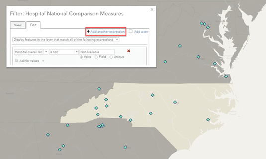
ArcGIS Living Atlas ၌ GIS အသုံးပြုသူများအတွက် လိုအပ်သည့် ပမာဏထက် ပိုမို များပြားသော Layer ဧရိယာများစွာ ရှိပါသည်။ GIS အသုံးပြုသူများသည် မိမိတို့ လိုအပ်သော ဧရိယာနယ်မြေရှိ ဒေတာ၊ ကြောင်းအရာ (content)များ ရှာဖွေရန်အတွက် Filterကို အသုံးပြုခြင်းအားဖြင့် လွယ်ကူစွာ ရွေးချယ် ရှာဖွေ ထုတ်ယူ အသုံးပြုနိုင်ပါသည်။
Webinar: အောက်ခံမြေပုံ(basemap) များစိတ်ကြိုက်ပြင်ဆင်သတ်မှတ်ခြင်း
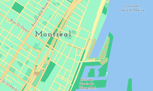
basemap များကို မိမိ စိတ်ကြိုက်ပြင်ဆင်သတ်မှတ်၍ အသုံးပြုနိုင်ပါသည်။ Vector tilesသည် ပြောင်းလဲနေသောမြေပုံများနှင့် သင့်လျော်သော အောက်ခံမြေပုံ (base map) များကို ပြုလုပ်နိုင်ပါသည်။ webinar တွင် ArcGIS Vector Tile Style Editor ကို စတင်အသုံးပြုနိုင်ရန် ဖော်ပြပေးထားပါသည်။
Content browser
ပိုမိုကောင်းမွန်သော မြေပုံများဖန်တီးနိုင်ရန် ဒေတာlayer နှင့် GIS content များမှ လုပ်ဆောင်ချက်များကို အသုံးပြု၍ ဖန်တီးနိုင်ပါသည်။
ပြဿနာများဖြေရှင်းရန်နှင့် အကြောင်းအရာများဖော်ပြရန်အတွက် အပြန်အလှန် တုံ့ပြန်သက်ရောက်မှု (interact)ဖြစ်နေသော အွန်လိုင်းမြေပုံ(web map)များ။

မြေပုံများ၊ scenes များ၊ လေ့လာဆန်းစစ်ခြင်းများအတွက် ဒေတာ layer ပြုလုပ်နိုင်ပါသည်။

3D မြင်ကွင်းများဖော်ပြခြင်းနှင့် ခွဲခြမ်းလေ့လာဆန်းစစ်ခြင်း။

လုပ်ငန်းစဉ်များနှင့် မြေပုံဗဟိုပြု toolsများကို အသုံးပြုနိုင်ပါသည်။

The ArcGIS Living Atlas of the World စတင်အသုံးပြုရန်
လေ့လာရန်
Esri နှင့် အခြားသော အသုံးပြုသူ အဖွဲ့အစည်းများမှ ပြုလုပ်ထားသော မြေပုံများ၊ အက်ပလီကေးရှင်း(application) များနှင့် ဒေတာ များအား လေ့လာနိုင်ပါသည်။
အကြောင်းအရာ (content)များပေါင်းစပ်အသုံးပြုခြင်း
မြေပုံအသစ်များ၊ အက်ပလီကေးရှင်း(Applications) အသစ်များ ပြုလုပ်ရန် အခြားအသုံးပြုသူများနှင့် ပူးပေါင်းဆောင်ရွက်နိုင်သည်၊
အချက်အလက်များရယူပါ
မိမိ ဖော်ပြလိုသော ဒေတာအချက်အလက်များကို ရှာဖွေရယူနိုင်ပါသည်။

အကြောင်းအရာ(content) များပေါင်းစပ်ရန် စတင်အသုံးပြုလိုက်ပါ
ArcGIS Online Map Viewer မှ ဒေတာများကို မိမိလုပ်ငန်းတွင် ထည့်သွင်း အသုံးပြုနိုင်ပါသည်။
ဒေတာများ
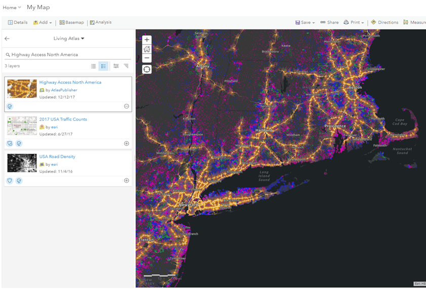
Map Viewer မှာ ဒေတာ များကို အသုံးပြု၍ အချိန်တိုအတွင်း မြေပုံအသစ်များ ပြုလုပ်နိုင်ပါသည်။ ArcGIS Living Atlas of the World မှ ဒေတာ layer များနှင့် မိမိဒေတာများ ပေါင်းစပ် အသုံးပြုနိုင်ပါသည်။
ပါဝင်ဆွေးနွေးလိုက်ပါ
ArcGIS Living Atlas of the World တွင် မိမိ၏ အတွေးအမြင်းများကို မျှဝေနိုင်ပြီး၊ အခြားသူဆီမှလည်း အတွေ့အကြုံများ လေ့လာနိုင်ပါသည်။
GeoNet အကြောင်းလေ့လာရန်
General info
What is the ArcGIS Living Atlas of the World?
How do users access this information?
Where can I get more information on the types of items available through the Living Atlas?
How much does it cost to use or contribute to the Living Atlas?
Contribute
Can I contribute to the Living Atlas?
I nominated an item for the Living Atlas. What happens now?
My item has been accepted into the Living Atlas. How do I find it?
Why would I want to contribute?
Community Maps Program
What is the Community Maps Program?
How do I contribute data to Community Maps?
What types of data does Community Maps accept?
Is there any pre-processing that needs to happen before the data is accepted for Community Maps?
How much does it cost to use the layers and basemaps or to contribute to Community Maps?
Do I retain control over my data?
Does Esri redistribute my contributed data?
How is Community Maps different from ArcGIS Open Data?

